


وصف لـ Magic Earth Navigation & Maps
Find the best route to your destination even without an internet connection. Magic Earth uses OpenStreetMap data and a powerful search engine to offer you the optimal routes for driving, biking, hiking and public transportation.
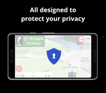
PRIVACY FIRST!
• We do not track you. We do not profile you. We do not trade in your personal data; moreover, we do not have it.
MAPS
• Save big on mobile internet costs and navigate reliably with offline maps powered by OpenStreetMap. 233 countries and regions are ready to be downloaded.
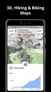
• Choose between 2D, 3D and Satellite map views.
• Get ready for travel and know every detail of your route like surface, difficulty, distance and elevation profile.
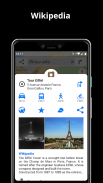
• Learn more about the points of interest near you from Wikipedia articles.
• Spot nearby parking places to easily park your car.
• Stay up-to-date and enjoy regular free map updates.
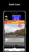
AI DASHCAM
• Improve safe driving and avoid accidents. Receive alerts to potential problems on the road and record your trip.
• AI DashCam features Driver Assistance warnings and Dash Cam functionality.
• Avoid collisions and accidents with Driver Assistance warnings: Headway Warning, Forward Collision Warning, Pedestrian Collision Warning, Lane Departure Warning, Leaving Lane Warning, Stop & Go Assist.
• Record the road ahead during navigation to have an aid in the event of a collision or incident.
• Driver Assistance warnings and Recordings are available when the device is on a car mount in landscape mode, with a clear view of the road ahead.
* AI DashCam (with Driver Assistance warnings and Dash Cam functionality) requires Android 7 or later.
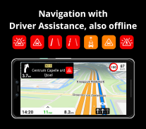
NAVIGATION
• Find the fastest or the shortest route to your destination when you travel by car, bike, on foot or with public transport.
• Plan your route with multiple waypoints.
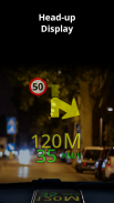
• Stay safe with the free Head-up Display (HUD) feature which projects the most important navigation info onto the windshield of your car.
• Know in advance which lane to take with precise turn-by-turn navigation and lane assistance.
• Get notified about speed cameras and stay up to date with current speed limits.
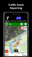
TRAFFIC INFO
• Get real-time traffic info, updated every minute.
• Discover alternative routes that avoid the traffic jams and save you time on the road.
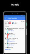
PUBLIC TRANSPORT
• Get around town quickly and easily. Choose from public transit routes that combine all transportation modes: bus / metro / subway / light rail / train / ferry
• Get walking directions, transfer times, departure times, number of stops. And when available, the cost.
• Find wheelchair or bike friendly public transportation.
WEATHER
• View current temperature and local weather forecast for your favorite locations.
• See what weather conditions to expect in the next hours and view the forecast for the next 14 days.
NOTES:
* Some features are not available in all countries.
* Some features require internet connection.
ابحث عن أفضل طريق إلى وجهتك حتى بدون اتصال بالإنترنت. يستخدم Magic Earth بيانات OpenStreetMap ومحرك بحث قوي لتقديم أفضل الطرق للقيادة وركوب الدراجات والمشي لمسافات طويلة والنقل العام.
الخصوصية أولاً!
• نحن لا تتبعك. نحن لا الملف الشخصي لك. نحن لا نتداول في بياناتك الشخصية ؛ علاوة على ذلك ، ليس لدينا.
MAPS
• وفر الكثير على تكاليف الإنترنت عبر الهاتف المحمول والتنقل بشكل موثوق به باستخدام الخرائط دون اتصال التي تدعمها خريطة الشارع المفتوح. 233 دولة ومنطقة جاهزة للتنزيل.
• اختر من بين 2D ، 3D وجهات النظر خريطة القمر الصناعي.
• الاستعداد للسفر ومعرفة كل التفاصيل من طريقك مثل السطح ، وصعوبة والمسافة والارتفاع الشخصية.
• معرفة المزيد حول النقاط المثيرة للاهتمام بالقرب منك من مقالات ويكيبيديا.
• بقعة أماكن وقوف السيارات القريبة لركن سيارتك بسهولة.
• كن محدثًا واستمتع بآخر تحديثات الخرائط المجانية.
AI DASHCAM
• تحسين القيادة الآمنة وتجنب الحوادث. تلقي تنبيهات للمشاكل المحتملة على الطريق وتسجيل رحلتك.
• يتميز AI DashCam بتحذيرات "مساعدة برنامج التشغيل" ووظائف Dash Cam.
• تجنب الاصطدامات والحوادث بتحذيرات "مساعدة السائق": تحذير التقدم ، تحذير الاصطدام الأمامي ، تحذير تصادم المشاة ، تحذير مغادرة المسار ، تحذير مغادرة المسار ، إيقاف المساعدة والإيقاف.
• سجل الطريق للأمام أثناء التنقل للحصول على مساعدة في حالة حدوث تصادم أو حادث.
• تتوفر تحذيرات وتسجيلات مساعدة برنامج التشغيل عندما يكون الجهاز على سيارة في وضع أفقي ، مع رؤية واضحة للطريق إلى الأمام.
* AI DashCam (مع تحذيرات مساعدة Driver و Dash Cam) تتطلب Android 7 أو إصدار أحدث.
NAVIGATION
• ابحث عن أسرع أو أقصر طريق إلى وجهتك عندما تسافر بالسيارة أو الدراجة أو مشياً على الأقدام أو بواسطة وسائل النقل العام.
• خطط لمسارك مع نقاط طريق متعددة.
• حافظ على سلامتك بفضل ميزة العرض المجاني (HUD) التي تعرض أهم معلومات التنقل على الزجاج الأمامي لسيارتك.
• معرفة مقدما أي حارة يجب اتخاذها مع التنقل الدقيق والمساعدة الحارة.
• الحصول على إخطار حول كاميرات السرعة والبقاء حتى الآن مع حدود السرعة الحالية.
TRAFFIC INFO
• الحصول على معلومات المرور في الوقت الحقيقي ، وتحديثها كل دقيقة.
• اكتشف طرقًا بديلة تتجنب الاختناقات المرورية وتوفر لك الوقت على الطريق.
PUBLIC TRANSPORT
• تجول في المدينة بسرعة وسهولة. اختر من طرق النقل العام التي تجمع بين جميع وسائط النقل: الحافلات / المترو / المترو / السكك الحديدية الخفيفة / القطار / العبارة
• احصل على اتجاهات المشي ، وأوقات النقل ، وأوقات المغادرة ، وعدد التوقفات. وعندما تكون متاحة ، فإن التكلفة.
• البحث عن كرسي متحرك أو وسائل النقل العام الصديقة للدراجة.
الطقس
• عرض درجة الحرارة الحالية وتوقعات الطقس المحلية للمواقع المفضلة لديك.
• انظر ما هي الظروف الجوية المتوقعة في الساعات القادمة وعرض التوقعات لمدة 14 يوما القادمة.
ملاحظات:
* بعض الميزات غير متوفرة في جميع البلدان.
* بعض الميزات تتطلب اتصال بالإنترنت.
Magic Earth Navigation & Maps - إصدار 7.1.24.8.9F594CB0.00F375F4
(23-02-2024)

Magic Earth Navigation & Maps - معلومات APK
نُسخة APK: 7.1.24.8.9F594CB0.00F375F4الحزمة: com.generalmagic.magicearthآخر إصدار من Magic Earth Navigation & Maps
تطبيقات من الفئة نفسها
قد يعجبك أيضًا...


